Crossing the Sands
Morecambe Bay contains the largest intertidal area in the whole of the UK. Twice a day, the ebbing tide reveals around 120 square miles (310 km2) of mudflats and sands, only for it all to disappear beneath the waves again as soon as the sea returns.
Despite the risks posed by quicksands, shifting channels and racing tides, this enormous flat expanse of sand has always provided a tempting alternative to the long, slow journey around the coast of the bay. The crossing of the sands has a long and varied history. From Roman generals and medieval monks to market traders and tourists, all kinds of people have crossed the sands for one reason or another. In fact the route was so well used that the areas of Furness and Cartmel on the western side of the bay were historically a part of Lancashire, called North Lonsdale. This enclave was known as 'Lancashire Beyond the Sands' or 'Lancashire North of the Sands' until the reorganisation of county boundaries in 1974.
The over-sands route across the bay has been described by some as the most dangerous highway in Britain, while others have found the crossing simply sublime. In mild weather, with good tides, the journey must have been a very pleasant one, but in harsh weather it must have been quite frightening - as first hand accounts attest:
'On a fine day there is not a more pleasant sea ride in the Kingdom. On the right, a bold shore, deeply indented in some places, and opening into bays in others... mountains beyond mountains and others again just see over them'. – Father Thomas West, 1774.
'A melancholy ride... The prospect on all sides quite savage, high barren hills indented by the sea, and dreary wet sands, rendered more horrible by the approach of night.' – T. Pennant, 1772.
‘From the (Furness) Abbey we returned to Ulverston, and from thence crossed the sands of Lancaster, a ride singularly interesting and sublime…We took the early part of the tide, and entered these vast and desolate places before the sea had entirely left them or the morning mists were sufficiently dissipated…The body of the sea, on the right, was still involved, and the distant mountains on our left, that crowned the bay, were still viewless: but it was sublimely interesting to watch the heavy vapours beginning to move…and as they gradually dissipated, discovering through their veil the various objects they had concealed…’ – Ann Radcliffe, 1794.
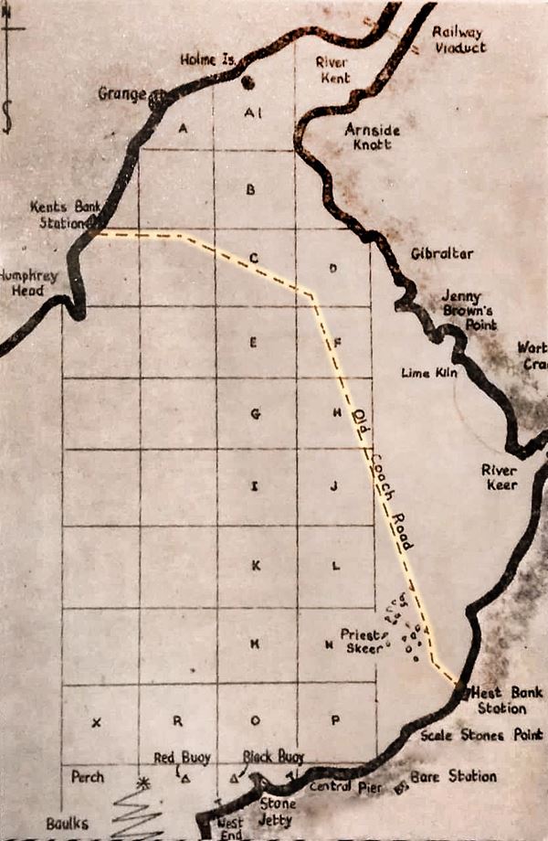
The most widely used route across the sands of Morecambe Bay ran between Hest Bank on the eastern shore, a couple of miles north of Lancaster, and Kents Bank on the western side of the Kent estuary, close to Cartmel and Grange-over-Sands. It's thought that General Agricola used this route as early as 79 AD, and that other Romans often crossed in the same way. Local people had probably been doing the same since prehistoric times, but left no record of their passing.
After the Romans left Britain the route remained in use, but the next people to leave surviving records of their crossings were the monks of Furness Abbey, a millennium later. The abbey was a large and wealthy institution. During its early years, various inhabitants of Bolton-le-Sands donated land to the monks, including Henry, son of Robert of Bolton, in 1230 AD. By the time of King Henry VIII’s dissolution of the monasteries in 1537, some 370 acres of village land was owned by the Abbey. Monks from this community would regularly cross the bay from Bolton-le-Sands to avoid the long and difficult journey by road, as did many other travellers.
In 1322, Robert the Bruce and his marauding army used the oversands route to invade England, before marching on to burn the town of Lancaster.
In the Middle Ages a chantry was built in Bolton-le-Sands so that travellers who had crossed safely had somewhere to give thanks, and those about to cross could pray for a safe journey. Although its location is unknown, it's thought to have stood somewhere along St. Nicholas Lane, which was the road commonly used by travellers. The same route was still in use as late as the 19th century.
.jpg)
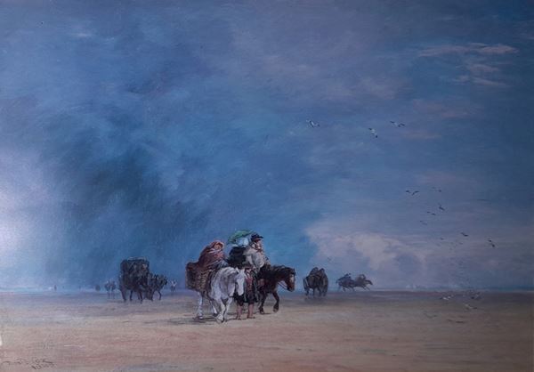
The dangers of the quicksand and ever-changing tides made it essential that travellers should have the help of a guide. From the Middle Ages two local priories paid guides or 'carters' to conduct travellers across nearby rivers - the most difficult parts of the journey over the sands. Cartmel Priory privided a guide for the Kent estuary, while Conishead Priory covered the crossing of the Leven Sands. After the Dissolution of the Monasteries, the Duchy of Lancaster took over the responsibility of employing guides. The Duke of Lancaster is always the reigning monarch, so the guides became known from this time as the King's Guides or Queen's Guides.
In the 19th century their salaries passed into the control of Charity Commissioners, and gradually their role became what it is today. The oversands route across the bay is no longer used for routine travel, but guided walks have instead become a popular summer activity for locals and visitors alike. The current King's Guide to the Sands is Michael Wilson, a Flookburgh fisherman with a lifetime of expertise in navigating the unique environment of Morecambe Bay.
You can find out more about the work of the guides or sign up for a cross-bay walk here: Guide over Sands Trust.
'The Carter seems a cheerful and pleasant fellow. He wore a rough great-coat and a pair of jack-boots, and was mounted on a good horse, which appeared to have been up to the ribs in water. When we came to him he recommended us to wait till the arrival of the coach, which was nearly a mile distant, as the tide would then be gone further out.' - Edward Baines, 1828.
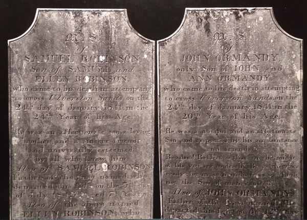
Despite the efforts of the guides, many people have still come to grief while crossing the sands. The Cartmel parish registers list 141 deaths over three centuries. Another local parish recorded a dozen cases of drowning over the course of 80 years. Tombstones to many of these people can be found in churchyards all around the bay, but there must have been many more whose bodies were never found and whose disappearance went unrecorded.
Quicksand, fog and the speed of the incoming tide were - and still are - the most common causes of accidents on the sands. One of the earliest surviving records dates from 1269, when Michael de Furness stayed too long (and perhaps dined too well) with the Prior of Cartmel and was drowned on his return journey to Aldingham that evening.
Accounts of some incidents imply that they were due to the foolhardiness of the victims, such as Christopher Harrys of Cartmel, a draper and grocer who often used packhorses to carry his goods across the sands in the late 17th century. When one of his horses faltered and lost its load, Harrys refused to go on despite several warnings from other travellers, and spent so long trying to retrieve his goods that he was caught and drowned by the incoming tide. Other accidents seem to have been down to sheer bad luck, such as the group of seven farnhands who all died when their cart fell into deep water on the way to a hiring fair in Lancaster in 1857.
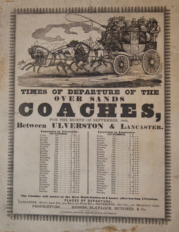
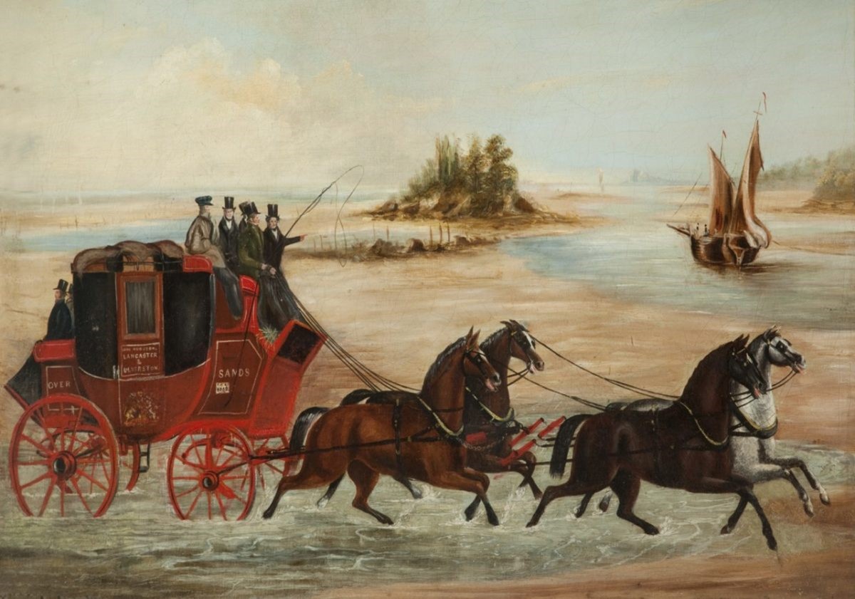
The oversands route across the bay was used for thousands of years by people travelling on foot, on horseback, or with horse-drawn carts and heavy wagons. Yet scheduled stagecoaches for passengers began quite late. The earliest coach travel over the sands began in 1781 in the form of a light diligence or ‘dilly’, which seated only 3 passengers. It travelled between Lancaster and Ulverston, using the oversands route between Hest Bank and Kents Bank.
In 1785 a more substantial coach took over which held up to thirteen people as well as heavy luggage. Guides met and directed them for the most difficult parts of the journey at the river crossings. These coaches ran every day except Sunday and were pulled by four horses, but they frequently got stuck because of their weight. This often meant leaving the coach in the sand, cutting the horses free and passengers having to walk to the nearest shore, sometimes carrying their luggage! Some were not so lucky. In 1821 a mail coach got stuck and the driver unfortunately drowned while trying to free the horses. In another incident a coach called the Whitehaven Belle overturned, and two of the horses were drowned. Lighter and faster coaches were soon introduced to reduce the risk of getting bogged down.
The Hest Bank Inn, once called The Sandes Inn, was the staging post and service halt for the daily stagecoach crossings. It was first licensed to brew mead, ale, sack, honey beer and sold cooked game. However the risks of the crossing and the reliance of the coaches on tide times meant that they were easily driven off by the new cross-bay railway line between Lancaster and Ulverston when it opened in 1857, offering a safe and convenient alternative.